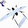
| Model: | HAWK-EAGLE-01 |
|---|---|
| Brand: | hongyi |
| Origin: | Made In China |
| Category: | Transportation / Vehicles / Aviation |
| Label: | mapping uav , fixed wing uav , surveying drone |
| Price: |
US $27000
/ set
|
| Min. Order: | 1 set |
Product Description
Application: aerial mapping, police monitoring, power monitoring and marine monitoring.
1. Performance parameter:
|
Wing Span:2400mm |
length of UAV:2000mm |
|
Max takeoff weight:10kg |
Payload:2kg |
|
Empty weight:4kg |
Max flight time:2h |
|
Flight radius:80km |
Max Altitude:5000m |
|
Max flight speed:110km/h |
Cruising speed:90km/h |
Takeoff and landing type: vertical Wind loading rating: 10m/s
Control precision:0.05m Environmental temperature:-30ºC~50ºC
2. Product features
2.1 Simple structure: body segment assembly, easy installation, simple operation, more than 90% of the whole machine using composite materials, lightweight design, increase the load factor.
2.2 Vertical take-off and landing: no landing space and airspace requirements, high efficiency. The four-axis reinforced fixed-wing composite structure, focusing on solving the fixed-wing aircraft takes off splashes need special runway and venue issues.
2.3 RTK positioning: fixed-point landing, precision operation.
2.4 Equipped with a portable ground control station, the control software can be used to monitor the UAV's flight and operation status through the wireless data link in real time, and flexibly control the UAV's operational flights.
2.5 Autonomous flight: a key take off, safe and convenient.
2.6 Aviation-class reliability: Complete system monitoring warnings and emergency management logic. Equipped with self-developed route planning software, and quickly generate optimized flight shooting documents and mission reports.
2.7 Professional multispectral, hyper spectral camera and digital camera with a dedicated gesture stable PTZ, which can effectively control the image of the gesture, so that the aerial survey within the allowable error.
2.8 aircraft wind resistance, in the 6 wind weather conditions stable operation.
| Payment Terms: | LC/TT |
|---|---|
Member Information
| Dalian Huihang Science and Technology Development Co.,Ltd. | |
|---|---|
| Country/Region: | Liao Ning - China |
| Business Nature: | Manufacturer |
| Phone: | 42875056 |
| Contact: | Belinda Yu (sales manager) |
| Last Online: | 24 May, 2018 |
Related Products of this Company
-
Remote Control Fixed Wing VTOL Drone
US $27000
-
2018 agriculture UAV Drone Crop Sprayer
US $6300
-
2017 factory in stock 10L uav crop
US $6300
-
2017Latest Design Water Proof 10L Crop
US $6300


